AIRBORNE REMOTE
SENSING USING ARA-AWI TRISPECTRAL SCANNER
Airborne Research
Australia, Parafield Airport SA
PO Box 335 Salisbury
South SA 5106 ph 08 8182 4000
A cost effective means of rapid
assessment and monitoring of vegetation at the paddock or larger scale.
Agricultural and environmental managers need up-to-date information on
the state of health and vigour of different vegetation components such as
crops, pastures, native forest, planted forest, remnant and riparian
vegetation. Remote sensing techniques
provide important spatial information for this purpose. Airborne remote sensing
is a non-invasive, rapid and efficient method of generating large-scale geo-referenced
maps that can help identify areas within a field that need different treatments
in order to improve yields.
Airborne remote sensing can provide spatial detail finer than current
satellite technology can provide (with resolution less than one metre compared
to 20-30 metres from satellites) and it is possible to usefully distinguish
variations of vegetation or soil surface conditions at the paddock scale. Additionally, the flexibility in the
frequency and time of data acquisition means that imagery can be tied closely
to the phenomena being assessed. Although conventional aerial photographs can
be used for mapping, they have some drawbacks in terms of timeliness because
scanning of the film is required to enable data processing and analysis in a
digital environment. This means a longer time lag before the data is
available. More importantly, there is a
lack of spectral resolution and also an inability to obviate local shadows or
cloud shadow. This means that the use of computer techniques to truly intercompare
imagery of the same site obtained at different times is usually more practical
with scanner image data.
ARA uses a variety of remote sensing systems. The system briefly
described here is the ARA-AWI trispectral scanner – a ‘push-broom’ three
channel line scanner developed jointly by ARA and the Alfred Wegener Institute
of Germany (AWI). The term push-broom
means that the scanner measures the reflectance radiometric signal
simultaneously along a line across the flight path from the ground immediately
below the aircraft. That data is ingested and the aircraft moves forward and a
few milliseconds later another line is registered, and so on. The lines combine
to form a continuous scroll-type of digital image.
The scanner is flown in an ARA aircraft at a height of between 1,000 and
10,000 feet above ground level, depending on the spatial resolution required
(images with a resolution ranging from less than half a metre to five metres
can be produced depending on a combination of altitude, scanner field of view
and aircraft speed). Images are
registered as continuous 'scrolling' images composed of transverse lines with
2048 pixels. A two–kilometre swath
therefore has a cross-flight resolution of one metre. The along-flight resolution is matched to the
cross-flight resolution by adjusting the aircraft's forward speed. The 2048 pixel/line registration is several
times that of other systems and means that there are fewer, if any, 'split'
images to be combined and less wastage on margin overlap, and a greater area
can be covered in the same flight time.
Each pixel from the raw image is geometrically and radiometrically
corrected to eliminate distortions due to angle of view and to variations in
aircraft speed and pitch, roll and yaw.
Just as the
colour of each pixel on a TV or computer screen is created by combining three
colours (red, green and blue – hence RGB screens) to give all the hues that we
perceive, the trispectral scanner in RGB mode measures three components of the
natural colour in sunlight and from that data we can re-create closely the
original colour. Our scanner can operate
in Red, Green and Blue mode but it turns out to be more useful to use the three
channels of Green, Red and Near Infrared.
Near Infrared is invisible to humans.
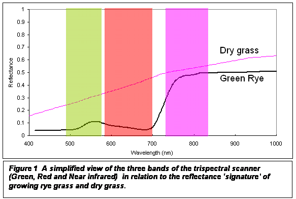
Figure 1 shows the ARA-AWI scanner bands in relation to two typical
spectral signatures. Firstly, note the
general difference in spectral signatures of dry grass and of vigorously
growing rye grass. A remarkable feature
is the large jump in response for the rye grass at about 750 nanometres in the
radiation that is invisible to us. This
turns out to be an inherent feature of healthy vegetation. Secondly, the rye grass has a minor peak in
the green band (which is why it appears green to us). Thirdly, the Near
infrared band is in the high reflectance region but the Red band, even though
it is fairly close, is not. Taking advantage of this feature, the satellite
sensing community has concentrated much research on the difference between the
Red and Near Infrared signals. So much
so that a useful parameter, the NDVI, has become commonly used. The NDVI is the normalised differential
vegetation index and is defined as the difference between the Near infrared and
Red band reflectances divided by their sum.
NDVI values vary with absorption of red light by plant chlorophyll and
the reflection of infrared radiation by water-filled leaf cells. In most cases
NDVI is correlated with photosynthesis. Because photosynthesis occurs in the
green parts of plant material the NDVI is normally used to estimate green
vegetation. By way of example, reference
to Figure 1 indicates that the NDVI of dry grass is about 0.15 and for growing
rye grass about 0.75.
Strictly
speaking, the data from the scanner are radiometric signals, not
reflectances. To derive reflectance
typically entails the use of calibration targets in the field and atmospheric
corrections. A partial solution is to
fly at a low altitude and to use ratios of signals. However, flying too low means that the edge
portions of the swath have large look-down angles if full use is made of the
swath width. Nevertheless, a series of
single band images from the signal data may be inspected and many interesting
features relating to vegetation and soil drawn out: some bands and computer enhancements
highlight particular features well. Exploratory manipulations of this type are
not possible with aerial photography.
There are many vegetation and soil conditions that can be detected at an
early stage using remotely sensed data and which are not easily detected visually.
Several products, ranging from false colour composites to more
sophisticated indices or digital image
classification, can be used to this end.
A significant advantage of using indices is that they 'normalise' the
data, reducing the effect of terrain variations and different sun angles or
shading within a scene or particular day.
The main index used is the NDVI, however other indices such as the
photosynthetic vigour ratio and the plant cell ratio, as well as false colour
imagery are available to agricultural users.
The advantage of the composite false colour imagery is that it has
texture, shadowing and shade effects which provide depth and contextual cues
and is more immediately 'absorbed' by the human. Imagery derived from indices is, at least in
theory, unaffected by shadow and texturing but is much more useful for computer
manipulation.
The photosynthetic vigour ratio (Green / Red) is high for leaves with
strong absorption of red light by chlorophyll.
This ratio may be useful in detecting, earlier than would otherwise be
the case, the yellowing-off of plants due to nutrient deficiency, disease,
fungus or insect attack.
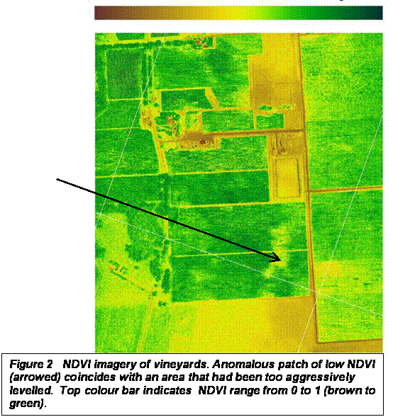
An example of the use of the NDVI is shown at Figure 2. Here the vines show up mostly as green (high
NDVI) but there is a spatial anomaly (arrowed) which was not readily apparent
visually either at ground level or from the air. From ground inspection by an agricultural
consultant, it was apparent that the affected vines were in a section where too
much of the original fertile top soil had been removed during
construction. As well, similar imagery
has allowed the early detection of differences in irrigation.
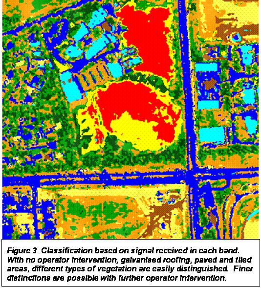
Additionally, different spectral and/or structural image classification
techniques can be applied. With GIS (Geographic
Information Systems), computerised maps of
parameters such as local yield, soil type and slope can be overlain on
the NDVI or other indices.
In other applications not directly related to viticulture, we have
demonstrated that galvanised iron roofing,
paving, roads, grass, trees can be differentiated in the imagery and quantified
and compared over time – all by computer with little or no operator
intervention. Mathematically, each pixel has three values associated with it.
There are mathematical techniques to analyse such data and “pull out” all those
pixels that have a signature close to some target signature which could be
weeds such as olive trees, illicit vegetation, water-logged areas, burnt areas,
salt-tolerant pasture grasses and different soil types as well as man-made
structures. For example, Figure 3
is an image from near
The important caveat remains:
changes in the remote sensing imagery effectively show variations in
vegetation and surface conditions, but do not tell the reason for those
variations. It is still necessary to go into the field to determine the reasons
for the observed variation.
The ultimate goal of detecting and managing field variability is to save
costs and/or to produce better yield quality or consistency. Some researchers have reported a potential
increase of net profits of more than $50 per hectare, as well as improved
administration and environmental benefits.
Depending on the area flown, the cost of processed digital imagery at
one metre spatial resolution is around a dollar or two per hectare. Therefore
imagery derived from the ARA-AWI trispectral scanner clearly has the potential
to be widely used as a cost-effective tool for rapid and flexible mapping of
variability in vineyards and other fields.
ARA provides the platform for all the State Government’s aerial
photography. As well as the trispectral
scanner ARA, operates other scanners and conventional cameras and video in our
own right or for other parties.
Further information: contact
Warwick Grace at Airborne Research